
Atacama Desert Landscapes: Exploring Chile’s Extraordinary Desert Landforms
Stretching across northern Chile between the Pacific coast and the Andes, the Atacama Desert contains some of the most unusual scenery in South America. The Atacama Desert Landscapes range from vast salt flats and wind-sculpted valleys to volcanic peaks, high-altitude lagoons, rocky plateaus, and fields of sand. Together, these landforms create an environment that often appears more like another planet than a familiar terrestrial desert.
The Atacama is widely recognized as one of the driest places on Earth and the driest non-polar desert. In some parts of its hyper-arid core, rainfall is extremely rare. The combination of persistent atmospheric conditions, the Andes rain shadow, and the influence of the cool Pacific Ocean has helped maintain this exceptional dryness.
Why Is the Atacama Desert So Dry?
The remarkable landscapes of the Atacama are closely connected to its climate. The Andes Mountains rise along the eastern side of the desert and restrict much of the moisture arriving from the interior of South America. As moist air moves toward the mountains, much of its precipitation falls before reaching the western side, creating a strong rain-shadow effect over northern Chile.
The Pacific coast adds another influence. The cold ocean current along western South America helps cool the lower atmosphere and limits the development of rain-producing clouds. Persistent high-pressure systems can further prevent storms from reaching the region.
Because significant rainfall is so uncommon, erosion and soil development occur differently here than in wetter landscapes. Rocks, sediments, salts, and volcanic deposits can remain exposed for long periods, helping produce the stark surfaces that characterize much of the Atacama.
Vast Salt Flats of the Atacama
Salt flats are among the most recognizable Atacama Desert Landscapes. The best-known example is Salar de Atacama, a broad enclosed basin surrounded by mountains and volcanoes.
Water occasionally flows down from the surrounding highlands, carrying dissolved minerals and fine sediments into low-lying basins. Because these basins have limited or no external drainage, much of the water eventually disappears through evaporation. Salts remain behind, gradually accumulating at or beneath the surface.
Over time, this process produces extensive salt crusts with irregular textures and pale surfaces. Beneath parts of Salar de Atacama are mineral-rich brines containing lithium and other dissolved salts. The resulting landscape combines geological processes, hydrology, and extreme evaporation on an enormous scale.
Valleys Shaped by Wind, Water, and Salt
Some of the desert’s most dramatic scenery lies in eroded valleys near San Pedro de Atacama. Valle de la Luna, or Moon Valley, is especially famous for its barren ridges, dunes, salt formations, and exposed sedimentary layers.
Despite the desert’s present dryness, water has played an important role in shaping many Atacama landforms. During wetter climatic periods, runoff cut channels through sediments and transported material from mountain slopes toward lower basins. Rare modern storms can still reshape parts of the desert.
Wind contributes to the process by moving loose sand and fine particles. Repeated erosion exposes layers of rock, clay, salt, and sediment, producing ridges, gullies, cliffs, and sculpted formations.
The combination explains why the Atacama is not simply a flat sandy desert. Much of it consists instead of rugged terrain where geological layers remain clearly visible.
Volcanoes Along the Andes
The eastern horizon of the Atacama is dominated by the Andes and a chain of large volcanoes. Their symmetrical cones and high summits form a striking contrast with the lower desert basins.
Northern Chile lies along an active tectonic margin where the Nazca Plate moves beneath the South American Plate. This subduction system is responsible for much of the volcanic activity associated with the Andes.
Volcanic rocks and soils contribute colors ranging from deep brown and reddish orange to gray and nearly black. NASA satellite observations show how the desert’s salt pans and sediment-filled gorges transition toward volcanic terrain and snow-covered high peaks.
At higher elevations, the environment becomes colder even though it remains extremely dry. Some volcanic summits and slopes retain patches of snow and ice, producing another dramatic contrast within the broader desert region.
High-Altitude Lagoons and the Altiplano
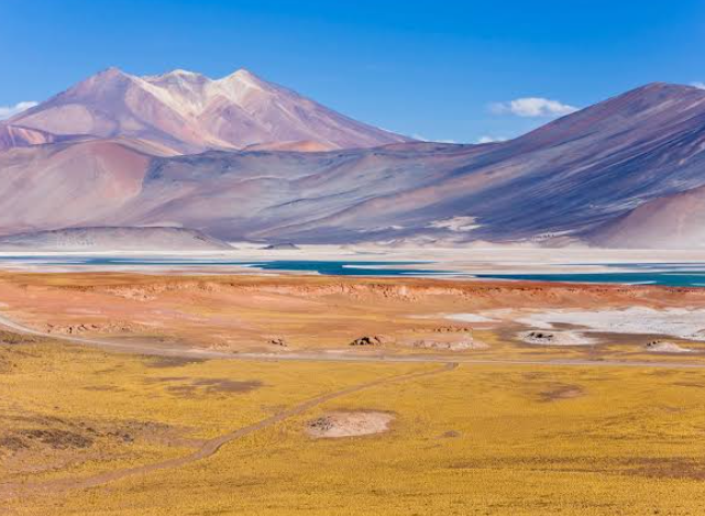
Beyond the lower desert lies the Altiplano, an elevated plateau characterized by volcanoes, salt basins, wetlands, and intensely colored lakes.
Lagoons such as Miscanti and Miñiques occupy enclosed high-altitude basins framed by volcanic mountains. Elsewhere, mineral-rich lakes and shallow wetlands interrupt otherwise dry terrain.
These bodies of water demonstrate that the Atacama is not uniformly waterless. Snowmelt, groundwater, springs, and limited seasonal precipitation can sustain isolated aquatic environments even in one of Earth’s driest regions.
The contrast is striking: pale salt deposits may sit beside blue lagoons, yellow grasslands, reddish volcanic rock, and distant mountains. This combination makes the high Andes one of the most visually diverse parts of the Atacama region.
Sand Dunes and Desert Plains
Although the Atacama is often imagined as a landscape dominated by sand, large portions are actually rocky, salty, or sediment-covered. Nevertheless, impressive dune fields occur where wind has accumulated loose material over time.
Some dunes form along valleys or near mountain slopes, while broad desert plains contain gravel, volcanic debris, and weathered rock. Wind repeatedly sorts and redistributes finer sediments, creating surfaces that range from smooth sand sheets to sharply defined dune ridges.
These landforms reveal how local topography determines the appearance of the desert. Even within relatively short distances, a traveler may move from rocky plateaus to dunes, salt flats, canyons, and volcanic foothills.
Why the Atacama Is Compared With Mars
The extreme dryness and barren appearance of parts of the Atacama have made the desert important to planetary science. NASA researchers have used the region to study organisms surviving under severe water stress and to test equipment designed for planetary exploration.
Its rocky ground, intense solar radiation, limited biological activity, and extremely low moisture levels provide conditions that can help scientists investigate questions related to Mars.
The comparison does not mean the Atacama is identical to Mars. Instead, certain environmental characteristics make it a useful terrestrial analogue for studying how life and technology function under exceptionally dry conditions.
A Landscape Created by Extremes
The beauty of Atacama Desert Landscapes comes from geological and climatic contrasts. Towering volcanoes rise beyond salt-encrusted basins, dry valleys cut through layered sediments, dunes develop beside rocky plains, and high-altitude lagoons appear unexpectedly within an otherwise arid environment.
Rather than being an empty wasteland, the Atacama is a complex geographical system shaped by tectonic activity, volcanism, evaporation, wind erosion, rare floods, ancient water movement, and one of the most extreme desert climates on Earth.
These processes have created a landscape where Earth’s geological history is unusually visible. For anyone interested in deserts, landforms, volcanology, or physical geography, the Atacama offers an exceptional example of how climate and geology can work together to shape the surface of a continent.