
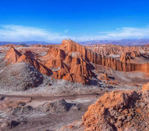
In northern Chile, the Atacama Desert contains a remarkable landscape of salt-covered ridges, sculpted cliffs, deep ravines, and sweeping sand dunes. This place is Valle de la Luna, or “Moon Valley,” one of the best-known natural landmarks near the desert town of San Pedro de Atacama.
Its name reflects the unusual appearance of the terrain. With sparse vegetation, exposed mineral deposits, sharp ridges, and broad areas of bare earth, the valley has often been compared to the surface of another planet. Yet the landscape is entirely the product of terrestrial geological processes that have been operating for millions of years.
Valle de la Luna provides an excellent example of how tectonic forces, salt deposits, wind, rare rainfall, and prolonged aridity can combine to create extraordinary desert landforms.
Where Is Valle de la Luna?
Valle de la Luna is located in the Atacama Desert of northern Chile, west of San Pedro de Atacama in the Antofagasta Region. Chile’s official tourism site places the attraction roughly 13 to 15 kilometers from San Pedro de Atacama.
The valley lies within the Cordillera de la Sal, or Salt Mountain Range, a narrow ridge system along the western side of the Salar de Atacama basin.
This position is important to understanding the scenery. Unlike a conventional mountain range composed mainly of hard crystalline rocks, the Cordillera de la Sal contains thick sedimentary and evaporite deposits that include clay-rich sediments, gypsum, and rock salt. Geological studies indicate that these materials were later folded and uplifted by tectonic deformation.
The resulting landscape forms a transition between the broad Salar de Atacama basin and the higher terrain farther west.
How Was Valle de la Luna Formed?
The story of Valle de la Luna begins long before the modern desert landscape existed.
Over geological time, sediments accumulated within the Atacama basin. Fine sediments, salts, gypsum, and other materials were deposited under changing environmental conditions. The Cordillera de la Sal preserves thousands of meters of continental sedimentary rocks associated with this long history.
Later tectonic deformation compressed and uplifted these layers. Salt behaves differently from many ordinary rocks because it can deform and move under pressure. Salt tectonics therefore contributed to the development of the Cordillera de la Sal and its folded structures.
Once these deposits were exposed at the surface, erosion began reshaping them.
Wind removed loose particles, while occasional rainfall cut channels through softer sediments. Salt was dissolved and redistributed by small amounts of water. Over long periods, these processes produced valleys, narrow ridges, cliffs, hollows, and irregular mineral formations.
The result is the complicated landscape visible today.
Why Is There So Much Salt?
Salt is one of the defining features of Valle de la Luna.
The broader Salar de Atacama region is an internally drained desert basin. Water entering such basins does not flow onward to an ocean. Instead, it collects in low areas and eventually disappears mainly through evaporation.
When mineral-rich water evaporates, dissolved salts remain behind. Repeated cycles of deposition can gradually produce thick evaporite layers.
The Cordillera de la Sal contains interbedded sediments, gypsum, and rock salt associated with ancient basin deposits.
In some places, salt appears as pale crusts on the surface. Elsewhere it is mixed with clay, sand, and other sediments, creating alternating colors and textures.
Rare rain can also dissolve exposed salt before evaporation causes minerals to crystallize again. This continuous interaction between salt and tiny amounts of moisture contributes to some of the valley’s most unusual surface features.
Wind and Water Sculpt the Desert
At first glance, it might seem that wind alone created Valle de la Luna. Wind erosion is certainly important, but water has also played a major role.
The Atacama is exceptionally dry, yet occasional rainfall can be geomorphically significant. When rain falls on steep, poorly vegetated slopes, water can move rapidly across the surface.
Temporary runoff cuts gullies, widens channels, transports sediment, and dissolves soluble minerals.
Research on the Cordillera de la Sal has documented how even scarce rainfall can dissolve exposed rock salt and contribute to distinctive salt-related landforms.
Wind then continues reshaping exposed surfaces by moving sand and fine sediment. Softer material may erode faster than harder or more resistant layers, gradually creating irregular ridges and sculpted formations.
These processes explain why an extremely dry place can still contain such complex erosional scenery.
The Great Dunes of Moon Valley
Sand dunes provide another striking contrast within Valle de la Luna.
Instead of covering the entire desert, sand accumulates where local topography and wind patterns allow loose grains to collect. Large dunes can therefore appear beside exposed sedimentary ridges and salt-covered formations.
One of the best-known areas is the Duna Mayor, or Great Dune.
From higher ground around this part of the valley, visitors can observe how dunes occupy depressions between rugged ridges. The smooth surfaces of the sand contrast sharply with the fractured and folded terrain nearby.
Official Chilean tourism information identifies Duna Mayor as one of the principal areas associated with visiting the valley.
The dunes demonstrate that Valle de la Luna is not one uniform type of desert landscape. It is a combination of depositional and erosional landforms occurring close together.
The Strange Shapes of the Cordillera de la Sal
Some of the most recognizable features of Valle de la Luna are its narrow pinnacles, sharp crests, and isolated formations.
Their shapes are strongly influenced by differences in the resistance of the underlying materials. Layers containing clay, salt, gypsum, and other sediments do not weather at exactly the same rate.
When erosion removes weaker material, more resistant portions can remain standing as ridges, columns, or unusual projections.
Among the best-known formations are Las Tres Marías, associated with a group of pillar-like mineral structures. Geological research in the area has described gypsum-rich formations and salt features produced by processes involving fractures, mineral precipitation, dissolution, and evaporation.
These formations show that the valley is not simply a collection of rocks shaped into unusual forms. Its appearance reflects the chemical properties of evaporite minerals as well as physical erosion.
Why Does Valle de la Luna Look Like the Moon?
The lunar comparison mainly comes from the absence of dense vegetation and the unusual combination of bare ridges, mineral crusts, dunes, and eroded depressions.
Chile’s official tourism authority describes the landscape as a mixture of stone, salt, dunes, crater-like forms, and sharp ridges sculpted over long periods.
However, Valle de la Luna should not be interpreted as an exact geological equivalent of the Moon.
The lunar surface is dominated by impact craters, volcanic plains, and processes that occur without Earth’s atmosphere, flowing water, or active weather systems. Valle de la Luna, by contrast, was created through sedimentation, tectonics, wind erosion, mineral dissolution, evaporation, and occasional water flow.
Its “lunar” quality is therefore primarily visual.
Colors Hidden in an Arid Landscape
Although the valley may initially appear dominated by brown and beige, closer observation reveals a much broader range of colors.
Red and orange tones can occur in oxidized sediments, while pale white surfaces often indicate salt or gypsum. Gray, cream, and darker brown layers reflect differences in mineral composition and sediment type.
These colors become especially noticeable when low-angle sunlight emphasizes ridges and geological layers.
The exposed surfaces effectively create a natural cross-section through the landscape, making differences between individual sedimentary units easier to see.
For this reason, Valle de la Luna is visually dramatic but also valuable as a place for observing desert geology.
A Natural Laboratory of Desert Geology
The importance of Valle de la Luna extends beyond its unusual appearance.
Within a relatively compact area, it displays many processes that shape arid environments: sediment accumulation, evaporite formation, tectonic uplift, salt deformation, wind erosion, occasional runoff, and dune development.
The valley also demonstrates an important principle of desert geography. Deserts are not simply enormous fields of sand. They can contain mountains, salt deposits, rocky surfaces, sedimentary basins, canyons, dunes, and highly specialized erosional landforms.
At Valle de la Luna, these different features occur together within the Cordillera de la Sal, creating one of the Atacama Desert’s most recognizable landscapes.
Its extraordinary terrain is therefore more than a resemblance to another world. It is a record of changing environments, tectonic forces, mineral deposition, and erosion—a landscape shaped over millions of years by some of the fundamental processes that continually transform Earth’s surface.