
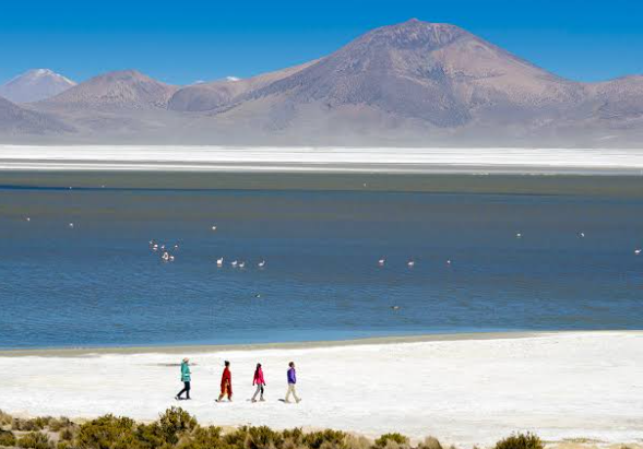
High in the Andes of northern Chile lies Salar de Surire, a vast salt flat surrounded by volcanic mountains, shallow saline lagoons, wetlands, and open high-altitude grasslands. Located in the Arica y Parinacota Region, this remote landscape sits at more than 4,000 meters above sea level and forms one of the most important wetland ecosystems of the Chilean Altiplano.
Unlike a completely dry salt pan, Salar de Surire includes both exposed salt crust and permanent or seasonally fluctuating saline waters. These environments provide habitat for flamingos, vicuñas, Andean birds, and specialized high-altitude vegetation. The area is protected as the Salar de Surire Natural Monument and is also recognized as a Ramsar Wetland of International Importance.
Where Is Salar de Surire?
Salar de Surire lies in the commune of Putre in Parinacota Province, northern Chile. It forms part of the Lauca Biosphere Reserve and occupies a remote section of the Altiplano near the Bolivian border.
The protected natural monument covers more than 11,000 hectares, while the broader Ramsar wetland is listed at approximately 15,858 hectares. The salar lies at an average elevation of around 4,200 meters.
At this altitude, the environment is cold, windy, dry, and exposed to intense solar radiation. Temperatures can change sharply between day and night, and oxygen levels are much lower than at sea level.
Despite these severe conditions, water, salt, and vegetation combine to create one of the most biologically important landscapes in the northern Chilean Andes.
How Did Salar de Surire Form?
Salar de Surire occupies an endorheic basin, meaning that water entering the basin has no direct outlet to the ocean.
Streams, springs, snowmelt, and groundwater carry dissolved minerals from the surrounding volcanic mountains into the basin. Because the climate is extremely dry, much of this water is gradually lost through evaporation.
The minerals remain behind.
Over long periods, repeated cycles of mineral transport and evaporation create salt crusts, saline sediments, shallow lagoons, and underground brines.
Geological descriptions of Salar de Surire identify calcium and boron salts among the important mineral deposits. The basin also contains highly saline shallow lagoons surrounded by wetland areas known as bofedales.
Why Is the Salt Flat White?
The pale surface of Salar de Surire results from the accumulation of evaporite minerals.
When mineral-rich water reaches the lower parts of the basin, evaporation removes the water while dissolved salts crystallize at or near the surface.
Over time, these deposits create extensive white or pale crusts.
However, the salar is not uniformly white. Some sections contain shallow water, darker sediments, wetlands, and mineral-rich mud. Seasonal changes in water levels can also alter the appearance of different areas.
This creates strong visual contrasts between bright salt, blue-gray lagoons, yellow-green vegetation, and the brown or reddish mountains surrounding the basin.
Three Species of Flamingos Live Here
One of the most remarkable features of Salar de Surire is its importance for flamingos.
Chile’s National Forest Corporation identifies three flamingo species that occur permanently within the protected area: the Chilean flamingo, the Andean flamingo, and James’s flamingo.
These birds feed in shallow saline water where microorganisms, algae, and small aquatic organisms are available.
Their specialized bills allow them to filter food from the water and sediment.
The Salar de Surire wetland is particularly important because it provides feeding and breeding habitat in a region where suitable high-altitude wetlands are widely separated.
Ramsar documentation has identified the site as one of Chile’s important areas for flamingo reproduction.
Vicuñas Across the Altiplano
Flamingos are not the only animals associated with the salar.
Vicuñas are frequently seen on the surrounding plains. These wild relatives of llamas are highly adapted to the cold, dry environment of the Andes.
Other mammals recorded in the protected area include pumas, culpeo foxes, vizcachas, and puna armadillos. Llamas and alpacas are also associated with the wider high-Andean landscape.
The combination of salt flats, shallow lakes, grasslands, and rocky terrain creates different habitats within a relatively compact area.
This diversity helps explain why Salar de Surire supports much more wildlife than its barren appearance might initially suggest.
Bofedales Bring Life to the Salt Flat
Around parts of the salar are bofedales, high-Andean wetlands formed where groundwater or surface water remains available close to the surface.
These wetlands support grasses and cushion plants that can survive at high elevations.
Geological and environmental records identify several bofedales around Salar de Surire, including areas near the Polloquere hot springs, the Surire River alluvial fan, and other parts of the basin.
Bofedales are ecologically important because they provide water and food for animals in an otherwise extremely dry environment.
Vicuñas, birds, and domesticated camelids can all depend on these wetland areas.
The Polloquere Hot Springs
One of the most unusual features of the Salar de Surire landscape is the presence of geothermal springs.
The Polloquere hot springs are located along the edge of the salar. CONAF reports that their waters can reach temperatures of around 60°C.
These springs reveal the continuing geothermal influence of the Andean volcanic region.
Hot groundwater rises toward the surface through fractures in the Earth’s crust, producing pools of warm mineral-rich water.
The contrast is striking: extremely cold nighttime temperatures and high-altitude winds can occur only a short distance from naturally heated water.
This combination of salt flats and geothermal activity is characteristic of many volcanic regions of the central Andes.
Volcanic Mountains Surround the Basin
The landscape around Salar de Surire is strongly influenced by Andean volcanism.
Volcanic peaks and broad mountain slopes surround the flat basin, creating a dramatic contrast between horizontal salt surfaces and steep terrain.
These volcanic rocks also contribute minerals to the hydrological system.
Water moving through or across volcanic material can dissolve minerals before carrying them into the closed basin below.
Over geological time, this contributes to the chemical composition of the salt flat.
The presence of hot springs further demonstrates that geothermal processes remain important in the region.
Why the Landscape Is So Colorful
Although salt flats are often associated with white surfaces, Salar de Surire includes a broad range of colors.
The salt itself may appear bright white or pale beige. Shallow water can look blue, gray, or green depending on depth, sediment, and light conditions.
Wetland vegetation introduces yellow and green tones.
The surrounding volcanic mountains range from brown and gray to red and purple.
Flamingos add another striking color to the landscape, with their pink plumage contrasting against the pale salt and dark mountains.
Because vegetation is sparse across much of the Altiplano, geological colors remain clearly visible.
A Ramsar Wetland of International Importance
Salar de Surire is not simply a scenic salt flat.
It is internationally recognized for its ecological significance.
The wetland was added to the Ramsar List in 1996 and includes permanent brackish lagoons associated with high-Andean salt flats.
Its importance comes largely from its role as habitat for flamingos and other specialized Andean species.
Protecting these wetlands is particularly important because they depend on limited and sensitive water systems. Changes in groundwater, mineral extraction, geothermal development, or climate can affect the balance between saline lagoons, bofedales, and surrounding habitats.
A Landscape Where Salt and Life Meet
Salar de Surire demonstrates that a salt flat is not necessarily an empty or lifeless environment.
Its landscape is shaped by a combination of closed-basin hydrology, intense evaporation, mineral deposition, volcanic geology, geothermal activity, and high-altitude climate.
White salt crusts stretch between shallow lagoons, while bofedales support vegetation and wildlife. Three species of flamingos use the wetland, vicuñas move across the surrounding plains, and geothermal springs emerge along the edge of the basin.
Together, these features make Salar de Surire one of northern Chile’s most distinctive high-Andean landscapes.
It is both a geological record of evaporation and volcanism and a living wetland ecosystem, showing how water, minerals, wildlife, and extreme climate can coexist more than 4,000 meters above sea level.