
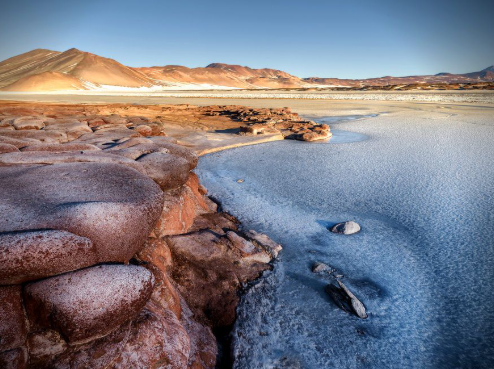
In the high-altitude landscapes southeast of San Pedro de Atacama lies Salar de Talar, one of northern Chile’s most visually distinctive salt-flat environments. Pale salt surfaces, turquoise water, reddish volcanic rocks, and multicolored mountains come together in a landscape that looks very different from the broad sandy deserts many people imagine when they think of the Atacama.
Salar de Talar is closely associated with the well-known Piedras Rojas, or “Red Stones,” where iron-rich rocks create intense reddish colors beside the pale salt flat and blue-green lagoons. The area lies at roughly 4,000 meters above sea level and forms part of the high Andean environment surrounding the Atacama Desert. Chile Travel
Where Is Salar de Talar?
Salar de Talar is located in Chile’s Antofagasta Region, southeast of San Pedro de Atacama and close to Route 23, which crosses the high Andes toward the Argentine border.
Official Chilean tourism information places the Piedras Rojas–Salar de Talar landscape approximately 150 kilometers from San Pedro de Atacama. The journey climbs above 4,000 meters in parts of the route, revealing increasingly open terrain, volcanic mountains, high-altitude grasslands, and saline basins. Chile Travel
Geologically, the salt flat occupies a basin surrounded by volcanic complexes. Chilean geological documentation describes the salar at an elevation of about 3,950 meters, with a salt-flat area of roughly 46 square kilometers and a drainage basin of approximately 476 square kilometers.
Why Does Salar de Talar Have Different Names?
The naming of this landscape can be confusing.
Geological sources describe the broader basin as Salar de Aguas Calientes Sur, or Aguas Calientes 3. Within this system, the northern portion is commonly called Aguas Calientes, while the southern part is known as Talar. Chile’s official biodiversity inventory also uses names such as “Salar de Aguas Calientes Sur 3 or Purisunchi Talar.”
Tourism material, however, often refers to the Piedras Rojas area simply as Salar de Talar.
These overlapping names reflect the fact that salt flats, lagoons, and wetland sectors form parts of a connected high-Andean basin rather than a single perfectly uniform surface.
How Did Salar de Talar Form?
Salar de Talar occupies an endorheic, or internally drained, basin.
In an endorheic basin, water flowing from surrounding mountains does not eventually reach the ocean. Instead, it collects in depressions where it may form temporary streams, shallow lagoons, wetlands, or groundwater systems.
Water carries dissolved minerals from volcanic rocks and sediments into the basin. Because the climate is dry and evaporation is intense, much of the water eventually disappears into the atmosphere.
The dissolved minerals remain behind.
Repeated cycles of runoff, groundwater movement, mineral concentration, and evaporation gradually create salt-rich sediments and crusts.
Chile’s biodiversity system officially places the Salar de Talar and Purisunchi sub-basin within the internally drained watersheds between the international border and Salar de Atacama. Simbio
A Salt Flat Surrounded by Volcanoes
Volcanic geology strongly influences the appearance of Salar de Talar.
The basin lies among volcanic formations ranging in age from the Miocene to the Quaternary. Geological surveys identify andesitic volcanic rocks and ignimbrites among the dominant materials around the salar.
To the west lies the Caichinque volcanic complex, while other volcanic mountains rise around the basin. Lava and volcanic debris have helped shape the surrounding topography.
These mountains are not uniformly colored. Depending on their mineral composition and weathering, their slopes can appear gray, purple, brown, orange, red, or ochre.
The contrast between those dark volcanic slopes and the pale salt basin is one of the defining visual characteristics of the region.
Why Are Piedras Rojas So Red?
Piedras Rojas is the most recognizable part of the Salar de Talar landscape.
The name means “Red Stones,” referring to broad areas of intensely colored rock near the saline waters.
According to Chile’s official tourism authority, the reddish coloration comes from the oxidation of iron within the rocks. This process produces strong red and rust-colored surfaces that contrast dramatically with white salt deposits and blue high-altitude water. Chile Travel
Iron oxidation is common in many arid landscapes. When iron-bearing minerals interact with oxygen, they can form iron oxides responsible for reddish and orange colors.
Because vegetation is sparse in this high-altitude environment, the mineral colors remain clearly visible instead of being hidden beneath dense plant cover.
What Does the Salt Crust Look Like?
The surface of Salar de Talar is not simply a smooth sheet of bright white salt.
Geological observations describe much of the crust as sulfate-rich and brownish, with locally occurring white salt deposits above it. Beneath the upper surface, additional saline layers can display orange coloration.
These differences reveal that a salar is a layered geological system.
Salt type, sediment content, water chemistry, groundwater depth, and evaporation can all affect the appearance of the surface.
Some areas may therefore look white and dry, while others contain brown, reddish, or damp mineral-rich sediments.
Lagoons and Wetlands Within the Basin
Despite its extreme dryness, the Salar de Talar region is not completely without water.
Chile’s official wetland inventory identifies permanent salar surfaces, lagoons, and high-Andean wet meadow environments within the Talar–Purisunchi system. One listed wetland covers more than 4,500 hectares and includes saline flats, several lagoon areas, and vega vegetation. Simbio
These water bodies are possible because high mountain basins collect runoff and groundwater from surrounding terrain.
Evaporation may be intense, but water can continue entering parts of the system through underground and surface pathways.
This creates a characteristic high-Andean pattern: apparently barren salt and volcanic terrain interrupted by narrow zones of water and vegetation.
Why the Water Appears Blue or Turquoise
The lagoons around Salar de Talar can display vivid blue, turquoise, or greenish tones.
Several factors influence how water appears, including depth, suspended minerals, dissolved salts, the color of the bottom sediments, and reflection from the sky.
Against the white and beige salt deposits, these saturated colors become especially noticeable.
The surrounding red rocks amplify the contrast even further.
This combination—red volcanic stone, white mineral deposits, turquoise water, and multicolored mountains—is what makes Piedras Rojas and Salar de Talar visually distinctive within the broader Atacama region.
Life in an Extreme High-Altitude Environment
The landscape may appear nearly lifeless, but the wider Talar basin includes specialized high-Andean vegetation.
Chile’s biodiversity records identify low tropical Andean shrub ecosystems dominated by species adapted to cold, dry, high-elevation conditions. Wetland areas also support vegetation where water remains available. Simbio
Life at this altitude must tolerate intense sunlight, strong winds, low nighttime temperatures, dry air, saline soils, and a short growing season.
As a result, plant cover is generally sparse compared with lower and wetter environments.
This limited vegetation also makes the geology unusually easy to observe.
Salar de Talar and the Wider Atacama Landscape
Salar de Talar belongs to a series of salt flats, lagoons, and volcanic basins scattered across the high Andes east of Salar de Atacama.
Nearby landscapes include the Miscanti and Miñiques lagoons, Laguna Tuyajto, and other internally drained basins.
Together, these features demonstrate that the Atacama is much more diverse than a conventional sandy desert.
Altitude changes can produce salt flats, volcanic plateaus, wetlands, lagoons, grasslands, snow-covered peaks, and barren rocky slopes within the same geographical region.
The high Andes are therefore an essential part of understanding the physical geography of the Atacama.
A Landscape Created by Salt, Water, and Volcanism
Salar de Talar is remarkable because several powerful geological and climatic processes are visible in one place.
Volcanic activity created much of the surrounding rock and topography. Water moving from the mountains transported dissolved minerals into an enclosed basin. Strong evaporation then concentrated those minerals, producing saline sediments and salt crusts.
At Piedras Rojas, oxidation transformed iron-rich rocks into brilliant red surfaces. Meanwhile, groundwater and runoff continue to support lagoons and small wetland environments within the otherwise arid landscape.
The result is not simply a salt flat, but a complex high-Andean system shaped by volcanism, hydrology, mineral chemistry, erosion, and extreme climate.
For anyone studying the geography of northern Chile, Salar de Talar provides a striking example of how water can shape even one of the driest landscapes on Earth.