
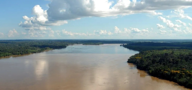
The Madeira River, one of the major tributaries of the Amazon, is vital for regional navigation and transport. However, its complex sediment dynamics pose significant challenges to safe and efficient navigation. This blog post will delve into the various navigation issues experienced along the Madeira River and how sediment transport impacts these challenges.
1. Key Navigation Challenges
One of the primary navigation challenges along the Madeira River is fluctuating water levels due to seasonal rain patterns. During the rainy season, water levels can rise significantly, exposing navigational hazards such as submerged rocks and sandbanks. Conversely, during the dry season, the lowering water levels can create navigational bottlenecks, which can lead to delays and additional costs for transport operators.
Another issue lies in the river’s width and meandering nature. Various parts of the river are subject to dramatic bends, requiring careful navigation to avoid running aground. Inexperienced navigators or operators unaware of changes can easily misjudge the turn radius, putting cargo and crew at risk and potentially leading to accidents. This complexity emphasizes the need for skilled pilots and modern navigational tools to ensure safe passage.
-
- Be aware of seasonal water level changes and plan trips accordingly.
-
- Invest in reliable navigational equipment to enhance accuracy.
-
- Train crew members on river navigation skills extensively.
-
- Consult local navigational charts that detail hazards and safe passages.
2. Sediment Transport Dynamics
Sediment transport in the Madeira River occurs in two primary forms: bed load and suspended load. Bed load consists of larger particles that move along the riverbed, while suspended load involves finer particles capable of remaining afloat for extended periods. The interplay of these two forms significantly affects the river’s morphology, leading to deep channel sections and shallower areas that directly impact navigation safety.
This sediment movement can lead to the formation of sandbars and islands, shifting from season to season. Understanding these dynamic sediment patterns is crucial for anticipating potential navigational hazards. For instance, while a sandbar may be navigable in one season, it might become a critical obstacle in another due to the changes in sediment distribution and river flow.
-
- Monitor sediment changes regularly to anticipate variations in navigability.
-
- Utilize remote sensing technology to study sediment dynamics.
-
- Implement sediment management practices to minimize navigational disruptions.
-
- Coordinate with local authorities for up-to-date hydrological data.
3. Mitigation Strategies for Navigation
To combat the challenges posed by navigation and sediment transport in the Madeira River, various mitigation strategies can be utilized. One effective approach is to enhance river dredging operations. Dredging can deepen critical channels and remove problematic sediments, ensuring safer navigation and minimizing the risk of grounding.
Another strategy involves establishing effective communication channels among stakeholders, including shipping companies, local authorities, and environmental organizations. Regular meetings can help facilitate the sharing of vital information related to seasonal changes, maintenance schedules, and sediment barriers. Such collaborations can bolster efforts toward safer navigation and sustained river health.
-
- Consider regular dredging to maintain navigable depths.
-
- Establish strong communication networks among riverine stakeholders.
-
- Conduct regular risk assessments related to sediment levels.
-
- Facilitate community outreach to raise awareness of navigation issues.
4. The Role of Technology in Enhancing Navigation
Advancements in technology play a significant role in overcoming navigation challenges along the Madeira River. Real-time monitoring systems utilizing satellite and radar technology can provide up-to-date information on water levels and sediment changes, allowing operators to make informed decisions. Such tools can greatly enhance the safety and efficiency of river navigation.
Moreover, the use of Geographic Information Systems (GIS) can facilitate better understanding and mapping of sediment transport patterns. By analyzing data, operators can identify problematic areas and adapt their routes accordingly, ensuring safer and more efficient journeys. With the right technological tools, the complexities of navigating the Madeira River become much more manageable.
-
- Invest in modern real-time monitoring systems for water levels.
-
- Adopt GIS technologies for detailed sediment analysis.
-
- Prioritize regular training on new technological tools for crew members.
-
- Stay updated on emerging technologies in river navigation.
In conclusion, the navigation challenges and sediment transport dynamics of the Madeira River present ongoing issues for transport operators. By understanding these challenges and implementing effective strategies and technologies, stakeholders can improve safety and efficiency. Don’t hesitate to consult with professionals who specialize in river navigation to ensure the best practices are being followed.