
High in the Andes of northern Chile lies Salar de Tara, a remote landscape where salt flats, shallow lagoons, wetlands, volcanic mountains, and unusual rock formations meet. Located in the Antofagasta Region near the borders with Bolivia and Argentina, this high-altitude wetland forms part of the wider protected landscape associated with Los Flamencos National Reserve.
Unlike the broad, dry salt crusts found elsewhere in the Atacama, Salar de Tara combines saline terrain with permanent brackish water, high-Andean grasslands, and important wildlife habitat. It is also internationally recognized as a Ramsar Wetland of International Importance, reflecting its ecological value far beyond its dramatic appearance.
Where Is Salar de Tara?
Salar de Tara lies in the high Andes east of San Pedro de Atacama. The landscape is situated at roughly 4,400 meters above sea level, placing it within the cold, dry environment of the Andean Altiplano and puna.
It is associated with Los Flamencos National Reserve, a protected area in the commune of San Pedro de Atacama. Official CONAF information identifies Tara and Aguas Calientes among the high-Andean sectors reached from the international road toward Paso de Jama.
At this elevation, conditions are very different from the lower Atacama Desert. Temperatures can vary sharply, winds are often strong, and vegetation is sparse. Nevertheless, wetlands and streams create pockets of biological productivity within an otherwise severe environment.
How Did Salar de Tara Form?
Like other Andean salt flats, Salar de Tara occupies an internally drained basin.
Water flowing from surrounding mountains and volcanic terrain enters lower areas but has no direct route to the ocean. Instead, it collects in depressions, lagoons, streams, and wetlands.
In such environments, evaporation gradually removes water while dissolved minerals remain behind. Repeated over long periods, this process contributes to the development of saline soils and salt-rich basins.
At Salar de Tara, the system is not completely dry. The Ramsar Convention describes it as a High Andean site containing a brackish lagoon maintained by surface waters flowing from surrounding mountains and volcanoes.
This continuing supply of water helps explain why Tara supports wetlands and wildlife rather than appearing as an entirely dry salt crust.
A Landscape Shaped by Volcanoes
Volcanism is one of the defining features of the wider Atacama Altiplano.
The mountains surrounding Salar de Tara are part of a region shaped by intense volcanic activity associated with the Andes. Thick deposits of volcanic material were laid down during major eruptions millions of years ago.
Some of the most striking rock formations around Tara are composed of ignimbrite, a rock formed from deposits produced by explosive volcanic eruptions. Local geological information links formations in the area with major ancient volcanic events, including eruptions associated with the Guacha and La Pacana volcanic systems. Scribd
After deposition, these volcanic materials were gradually modified by erosion, creating the isolated towers, cliffs, and irregular walls visible today.
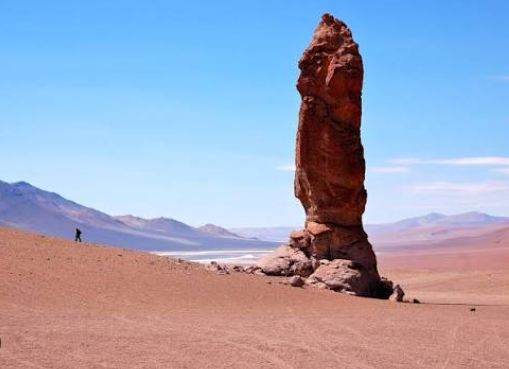
The Monjes de la Pacana
Among the most recognizable formations near Salar de Tara are the Monjes de la Pacana, or “Monks of La Pacana.”
These tall, isolated rock pillars rise dramatically from the otherwise open Altiplano landscape. Their vertical shapes have encouraged comparisons with standing human figures, which explains their name.
The pillars consist of volcanic ignimbrite that has been progressively sculpted by erosion. Wind and water removed weaker surrounding material while more resistant sections remained standing as towers. Geological descriptions associate the Monjes de la Pacana with Tara ignimbrite formed several million years ago.
Their presence illustrates how volcanic activity and erosion can work together to produce landforms that look almost artificial despite being entirely natural.
The Catedrales de Tara
Another distinctive geological feature is the Catedrales de Tara, or Cathedrals of Tara.
These formations consist of tall walls and pinnacles of eroded volcanic rock. Their irregular towers resemble the vertical architecture of a ruined cathedral, giving them their descriptive name.
Different ignimbrite layers can be observed within these formations, recording separate episodes of ancient volcanic activity. Over time, exposure to wind, runoff, temperature changes, and physical weathering carved the deposits into their present shapes.
Together, the Catedrales and the Monjes make the Salar de Tara region especially valuable for understanding the volcanic history of the central Andes.
Wetlands in an Extremely Dry Region
One of the most surprising aspects of Salar de Tara is the presence of wetlands within one of South America’s driest regions.
The site includes shallow lagoons as well as vegas and bofedales, high-Andean wet meadows that form where groundwater or surface water remains available.
These wetlands support grasses and other plants capable of surviving cold temperatures, strong winds, saline conditions, and high solar radiation.
Chile’s biodiversity information system identifies lakes, lagoons, rivers, salt flats, wet meadows, and bofedales within the wider Salar de Tara Ramsar area. Simbio
This mosaic of habitats makes the landscape more ecologically complex than its barren appearance might initially suggest.
Why Flamingos Are Important at Salar de Tara
Flamingos are among the best-known animals associated with Salar de Tara.
The wetland provides feeding, resting, and breeding habitat for high-Andean bird species. The Ramsar designation specifically recognizes Tara’s importance for flamingos, including James’s flamingo and the Chilean flamingo.
Chile’s official geological and environmental data also lists Andean flamingos among the bird species present in the area.
Recent conservation surveys underline this importance. In one summer census within and around Los Flamencos National Reserve, more than 5,000 flamingos were counted at Salar de Tara, making it one of the reserve’s major flamingo concentrations.
Their presence demonstrates that saline high-altitude wetlands can support surprisingly rich ecosystems.
Vicuñas and Other High-Andean Wildlife
Flamingos are not the only animals adapted to this environment.
Vicuñas can be found moving across the surrounding grasslands. These wild relatives of llamas are highly adapted to life at high elevations.
Other mammals recorded in the broader Tara ecosystem include vizcachas, culpeo foxes, pumas, Andean cats, and several small rodents. Waterfowl such as Andean gulls, puna ducks, giant coots, and other high-altitude birds also use the wetlands.
The combination of open steppe, wetlands, rocky terrain, and saline water creates several different ecological niches within a relatively compact region.
Why the Landscape Has So Many Colors
Salar de Tara is notable for its contrasts.
White and pale mineral deposits occupy parts of the basin, while shallow water may appear blue or turquoise. Yellow and golden grasses grow around wetter margins.
Surrounding volcanic mountains introduce shades of red, brown, gray, orange, and purple.
These colors reflect differences in rock type, mineral content, vegetation, sediment, and moisture. Iron-bearing volcanic materials can produce reddish or brown tones, while salts create much lighter surfaces.
Because vegetation is relatively sparse, geological colors remain clearly visible across the landscape.
A Fragile High-Andean Ecosystem
Despite its remote appearance, Salar de Tara is environmentally sensitive.
CONAF has emphasized its importance for biodiversity, scientific research, and the cultural heritage of local Lickanantay communities. The area has also been managed carefully because disturbance can affect nesting birds, wetlands, and other fragile habitats.
High-Andean wetlands are particularly vulnerable because their ecosystems depend on limited water supplies. Changes in hydrology, climate, human activity, or disturbance can have significant effects on vegetation and wildlife.
For this reason, Salar de Tara should be understood not simply as a scenic desert attraction but as an important conservation landscape.
Why Salar de Tara Is Geographically Remarkable
Salar de Tara brings together several of the processes that define the geography of northern Chile.
Ancient volcanic eruptions produced massive deposits of ignimbrite. Wind and water later sculpted those deposits into pillars and cliff-like formations. Mountain runoff feeds a closed high-altitude basin, while evaporation concentrates salts and creates saline wetlands.
At the same time, lagoons and bofedales support flamingos, vicuñas, waterbirds, and other species adapted to extreme Andean conditions.
The result is a landscape where geology, hydrology, climate, and ecology are closely connected. Rather than being simply another salt flat in the Atacama, Salar de Tara is a complex high-altitude wetland system—and one of the clearest examples of how water and life can persist within an exceptionally dry mountain environment.