
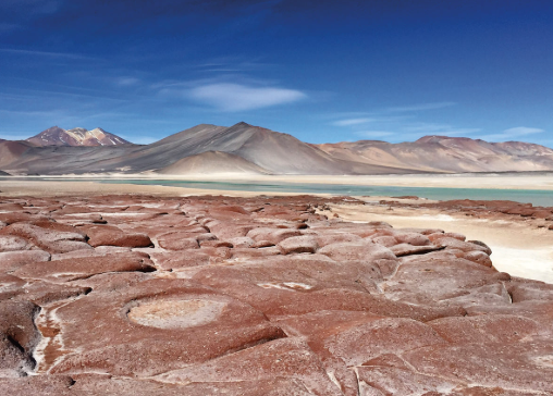
Northern Chile is home to some of the driest and most unusual landscapes on Earth. Among them, the Atacama Salt Flats stand out for their vast mineral surfaces, shallow lagoons, underground brines, volcanic surroundings, and specialized wildlife.
The term is often used broadly for the salt-covered basins of the Atacama region, but the most famous is Salar de Atacama. Located south of San Pedro de Atacama, it is the largest salt flat in Chile and one of the defining geographical features of the Atacama Desert. Its rough salt crust may appear almost lifeless from a distance, yet beneath and around it lies a complex system of groundwater, minerals, wetlands, and wildlife. Chile Travel
What Are the Atacama Salt Flats?
A salt flat, or salar in Spanish, is a low-lying basin where dissolved minerals accumulate as water evaporates.
Salar de Atacama occupies an enclosed basin surrounded by mountain ranges and volcanoes. Unlike a river basin that drains toward the sea, this landscape has no external drainage outlet. Water entering the basin ultimately disappears mainly through evaporation, leaving dissolved minerals behind. 地球宇航员摄影门户
Over long periods, repeated evaporation concentrates salts near the surface and within underground water. This process produces the extensive crusted landscape associated with the Atacama Salt Flats.
The result is not a perfectly smooth white plain. Much of the central salar is covered by rough, irregular salt formations, while wetter areas around its margins contain lagoons, softer sediments, and shallow groundwater.
How Did the Salt Flats Form?
The development of the Atacama salt basins is connected with geology, climate, and the surrounding Andes.
Water occasionally flows down from mountains and volcanic terrain into the enclosed basin. These flows carry dissolved minerals as well as gravel, sand, clay, and finer sediments.
The heavier materials tend to settle before reaching the lowest parts of the basin. Clay and dissolved salts can travel farther toward the salar.
NASA describes Salar de Atacama as a geologically dynamic system in which occasional flooding brings new sediments into the basin. Once water reaches the low-lying salt pan, there is no river carrying it away. As evaporation removes the water, salts remain and accumulate. NASA Science
Thousands of repeated cycles of inflow and evaporation gradually build thick salt-bearing deposits.
Why Is the Surface So Rough?
Photographs of some salt flats show smooth, almost perfectly flat white surfaces. Salar de Atacama can look quite different.
Its central area is characterized by hard and often extremely irregular salt crusts. USGS observations describe the center as a continuously dry surface dominated by sodium chloride crust. Because this area is not regularly submerged, the salt develops a rough texture instead of repeatedly dissolving into a smoother surface. Eros
Groundwater movement also contributes to variation across the salar.
Near its margins, changes in groundwater level can alternately dissolve and redeposit minerals. Clay and carbonate-rich materials create surfaces that differ from the harder salt crust farther inside the basin. NASA Science
These differences explain why the landscape changes noticeably when moving from the dry center toward lagoons and wetlands around the edges.
Where Does the Water Come From?
The existence of water in such an arid environment can seem surprising.
The Atacama receives extremely little rainfall, but the salt flat is connected to a much larger hydrological system. Water can enter the basin from rainfall and snow in surrounding highlands, mountain runoff, springs, and groundwater.
Some of this water moves underground before reaching lower elevations.
Because Salar de Atacama is a closed basin, water cannot simply continue toward the ocean. Instead, it accumulates temporarily in sediments, lagoons, and underground aquifers before eventually being lost through evaporation.
This creates a striking contrast: an apparently dry salt surface can have mineral-rich water hidden directly beneath it.
Brine Beneath the Salt Crust
One of the most important characteristics of Salar de Atacama is its subsurface brine.
Brine is water containing high concentrations of dissolved salts. Beneath portions of the salar, this water occupies pores and spaces within salt-bearing deposits.
The brines contain several dissolved minerals, including unusually high concentrations of lithium. USGS research describes Salar de Atacama as one of the world’s major examples of a lithium-bearing continental brine system. 美国地质调查局
This connection between geology and mineral resources has made the region economically important.
Lithium-bearing brine is pumped into shallow evaporation ponds, where the extremely dry and windy climate accelerates water loss and concentrates dissolved salts. The rectangular evaporation ponds can be clearly seen in satellite imagery. NASA Science
Why Lithium Occurs Here
Lithium-rich brine deposits usually require a particular combination of geographical conditions.
According to the USGS, important characteristics include an arid climate, a closed basin, suitable geological sources of lithium, tectonic subsidence, and enough time for brines to become concentrated. Volcanic or geothermal activity can also be associated with these systems. USGS
The Salar de Atacama possesses many of these characteristics.
Mountains and volcanic landscapes surround the basin, while extreme evaporation continually concentrates dissolved minerals. Because water does not drain outward, minerals can remain trapped and become increasingly concentrated over geological time.
This makes the salt flat not only a dramatic landform but also an important example of how climate and geology can work together to create mineral deposits.
Flamingos and Desert Lagoons
Despite the severe environment, the Atacama Salt Flats are not biologically empty.
Wetlands and shallow saline lagoons around the salar provide important habitat for wildlife. Laguna Chaxa, within Los Flamencos National Reserve, is particularly well known for its flamingos.
Chile’s National Forest Corporation lists three flamingo species associated with the reserve: the Andean flamingo, James’s flamingo, and Chilean flamingo. CONAF
These birds use saline wetlands for feeding and other parts of their life cycle. Their presence creates one of the most striking contrasts in the Atacama: pink flamingos moving through shallow water surrounded by rough salt crust and barren mountains.
Vegetation is also concentrated around wetter margins of the salar rather than across its driest central surface. CONAF
Volcanoes Around the Salt Flats
The scenery of Salar de Atacama extends far beyond the salt itself.
The eastern horizon is dominated by the Andes and volcanic peaks. Their dark, reddish, and brown slopes contrast strongly with pale salt deposits and shallow blue lagoons.
Volcanic rocks are part of the geological history of this region, and volcanic activity is also relevant to the development of mineral-rich closed basins.
From many parts of the salar, the landscape therefore appears layered: rough salt in the foreground, wetlands and desert plains farther away, and high volcanic mountains on the horizon.
This combination creates one of the most recognizable geographical scenes in northern Chile.
Salt Flats Are More Than Empty Deserts
At first sight, the Atacama salt landscape can appear static. In reality, it is continually influenced by groundwater movement, evaporation, mineral crystallization, occasional flooding, wind, and biological activity.
Some areas remain exceptionally dry, while others support lagoons and wetlands. Minerals accumulate beneath the surface, while salts repeatedly dissolve and crystallize near groundwater margins.
This makes the salar an excellent example of how a desert can contain an active hydrological system even when visible water is scarce.
A Landscape Shaped by Water and Evaporation
The Atacama Salt Flats demonstrate that some of the driest environments on Earth can still be fundamentally shaped by water.
Mountain runoff and groundwater carry minerals into enclosed basins. Intense evaporation removes water but leaves those minerals behind. Over time, this process creates salt crusts, concentrated brines, mineral-rich sediments, and saline lagoons.
Salar de Atacama brings all of these features together within a landscape surrounded by volcanic mountains and extreme desert terrain.
Its unusual geography makes it far more than a broad white surface in the Atacama Desert. It is a dynamic system where geology, hydrology, climate, mineral resources, and wildlife meet—revealing how even an exceptionally arid environment can support a remarkably complex landscape.